|
The village of La Benâte is a small village located west of France. The town of La Benâte is located in the department of Charente-Maritime of the french region Poitou-Charentes. The town of La Benâte is located in the township of Saint-Jean-d'Angély part of the district of Saint-Jean-d'Angély. The area code for La Benâte is 17040 (also known as code INSEE), and the La Benâte zip code is 17400.
Geography and map of La Benâte :
The altitude of the city hall of La Benâte is approximately 70 meters. The La Benâte surface is 11.07 km ². The latitude and longitude of La Benâte are 46.012 degrees North and 0.571 degrees West.
Nearby cities and towns of La Benâte are :
Landes (17380) at 3.10 km, Courant (17330) at 3.17 km, Lozay (17330) at 3.82 km, Nachamps (17380) at 4.17 km, Saint-Loup (17380) at 4.38 km, Saint-Denis-du-Pin (17400) at 4.49 km, La Vergne (17400) at 5.10 km, Puyrolland (17380) at 5.63 km.
(The distances to these nearby towns of La Benâte are calculated as the crow flies)
Population and housing of La Benâte :
The population of La Benâte was 402 in 1999, 410 in 2006 and 411 in 2007. The population density of La Benâte is 37.13 inhabitants per km². The number of housing of La Benâte was 190 in 2007. These homes of La Benâte consist of 155 main residences, 22 second or occasional homes and 13 vacant homes. |
|
|
Hotel La Benâte
|
|
|
Book now ! Best Price Guaranteed, no booking fees, pay at the hotel with our partner Booking.com, leader in online hotel reservation.
Find all hotels of La Benâte : Hotel La Benâte
| |
|
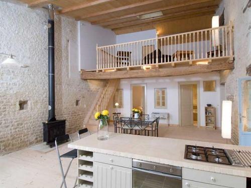
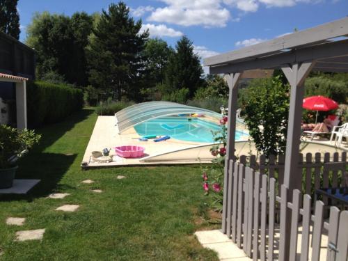
Guest accommodation : Le Batiment


Le Batiment is a converted cottage set 6 km from Saint-Jean-d'Angély and 3 km from the A10 motorway. It offers self-catering accommodation, a roof-top terrace, and Wi-Fi is free...
Address : 6 impasse des Roses 17400 La Benâte
Distance Guest accommodation - La Benâte : 1.55 km
|
|
|
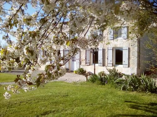
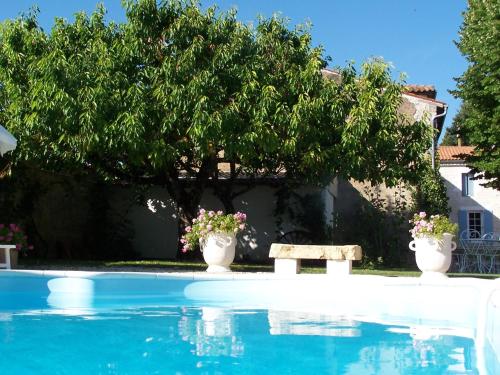
Bed and Breakfast : Maison Lavande
Featuring a seasonal outdoor pool, a barbecue and free WiFi, Maison Lavande offers pet-friendly accommodation in Saint Denis Du Pin. The bed and breakfast is located in a former...
Contact : Bourgneuf 25 Rue St Martin d'Auge 17400 Saint Denis Du Pin
Distance Bed and Breakfast - La Benâte : 4.98 km
|
|
|
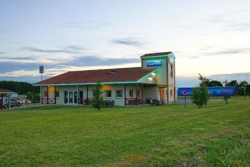
Hotel : Couett'Hotel Saint Jean d'Angély
Located in Saint-Jean-d'Angely in southwestern France, the Couett'Hotel features an on-site bar and en suite rooms with free Wi-Fi. The A10 Motorway access is 1.2 km away and fr...
Prices : from 49.00 €
to 65.00 €
Contact : 3 Rue De La Pierre Creuse ZA Le Moulinveau 17400 Saint-Jean-dʼAngély
Distance Hotel - La Benâte : 6.12 km
|
|
|
Guest accommodation : Petit Champagne
Offering access to a seasonal outdoor pool, Petit Champagne is located in Torxé, in the Poitou-Charentes Region. La Rochelle is 47 km from the property. Free private parking is ...
Contact : 293 Route de Landes 17380 Torxé
Distance Guest accommodation - La Benâte : 6.33 km
|
|
|
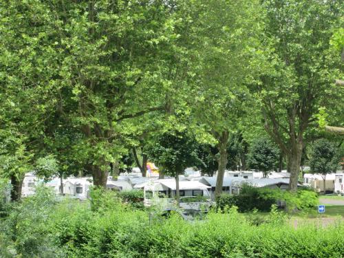
Guest accommodation : Camping Val de Boutonne
Camping Val de Boutonne provides accommodation with a seasonal outdoor swimming pool and free WiFi, and is situated in Saint-Jean-dʼAngély. A microwave and fridge are also offe...
Address : 56 quai de bernouet 17400 Saint-Jean-dʼAngély
Distance Guest accommodation - La Benâte : 7.47 km
|
|
|
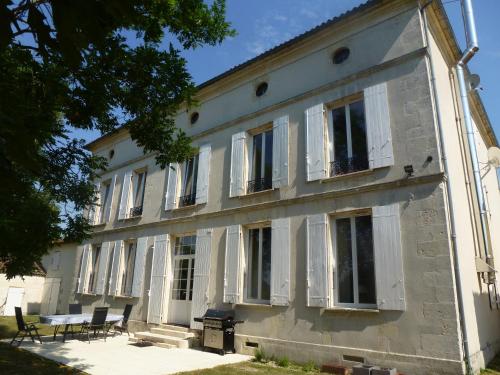
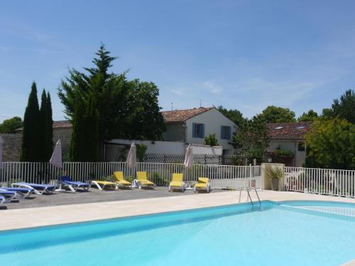
Guest accommodation : Domaine Les Granges
Offering 2 seasonal outdoor swimming pools, a restaurant and a bar, Domaine Les Granges is located 1 km from Saint-Jean-d’Angély city centre. Free WiFi access is available. The...
Prices : from 120.00 €
to 200.00 €
Contact : 55, chemin des Portes 17400 Saint-Jean-dʼAngély
Distance Guest accommodation - La Benâte : 7.58 km
|
|
|
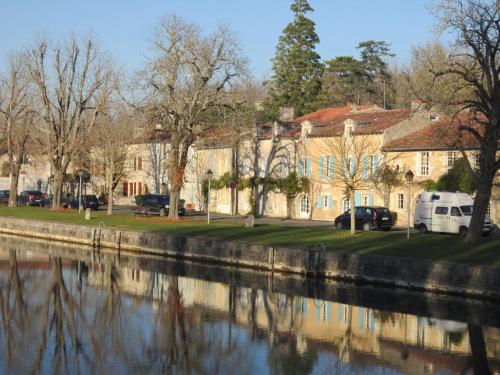
Bed and Breakfast : L'Etoile du Port
Located on the river bank, a 10-minute walk from the centre of Saint-Jean-d'Angély, this 17th-century property features individually decorated rooms with free Wi-Fi. A fireplace...
Contact : 14, Quai de Bernouet 17400 Saint-Jean-dʼAngély
Distance Bed and Breakfast - La Benâte : 7.85 km
|
|
|
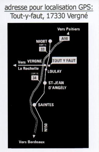
Hotel : Lx Hôtel
Situated in Vergné, Lx Hôtel features a terrace and free WiFi. At the hotel, rooms come with a wardrobe. The private bathroom is equipped with a shower. All guest rooms in Lx H...
Price : from 59.00 €
to 95.00 €
Contact : TOUT-Y-FAUT 17330 Vergné
Distance Hotel - La Benâte : 8.36 km
|
|
|
Apartment : Apartment Faubourg Taillebourg
Featuring an outdoor pool and pool views, Apartment Faubourg Taillebourg is set in Saint-Jean-dʼAngély. Guests staying at this apartment have access to free WiFi and a fully equ...
Address : 26 Faubourg Taillebourg 17400 Saint-Jean-dʼAngély
Distance Apartment - La Benâte : 8.82 km
|
|
|
Guest accommodation : Le Four à Pain
Set in the countryside of Courcelles, 2 km from the medieval market town of Saint-Jean-d'Angély, this guesthouse offers a heated outdoor swimming pool and rooms with private ent...
Rate : from 80.00 €
Contact : 1, rue du Bourg - village de Courcelles 17400 Saint-Jean-dʼAngély
Distance Guest accommodation - La Benâte : 9.86 km
|
|
Find another hotel near La Benâte : La Benâte hotels list
|
Map of La Benâte
|
|
Map of La Benâte :
At right you can find the localization of La Benâte on the map of France. Below, this is the satellite map of La Benâte. A road map, and maps templates of La Benâte are available here : "road map of La Benâte". This map show La Benâte seen by the satellite of Google Map. To see the streets of La Benâte or move on another zone, use the buttons "zoom" and "map" on top of this dynamic map.
Search on the map of La Benâte :
To search hotels, housings, tourist information office, administrations or other services, use the Google search integrated to the map on the following page : "map La Benâte".
Hotels of La Benâte are listed on the map with the following icons: 
The map of La Benâte is centred in the following coordinates :
|

|
|
|
|
Print the map of La Benâte

Print the map of La Benâte : map of La Benâte
|
Photos La Benâte
|
See all photos of La Benâte :
Other photos of La Benâte and nearby towns can be found here: photos La Benâte
|
|
La Benâte weather forecast
Find next hours and 7 days weather forecast for La Benâte here : weather La Benâte (with english metrics)
This is the last weather forecast for La Benâte collected by the nearest observation station of Saint-Jean-d'Angély.
Week Forecast:
The latest weather data for La Benâte were collected Friday, 31 July 2026 at 15:02 from the nearest observation station of Saint-Jean-d'Angély.
| Friday, July 31st |
29°C 18°C
38%
51%
|
Rain
Temperature Max: 29°C Temperature Min: 18°C
Precipitation Probability: 38% (Rain)
Percentage of sky occluded by clouds: 51%
Wind speed: 11 km/h East
Humidity: 65%° UV Index: 7
Sunrise: 06:43 Sunset: 21:33 |
|
| | Saturday, August 1st |
29°C 17°C
13%
47%
|
Partly cloudy
Temperature Max: 29°C Temperature Min: 17°C
Precipitation Probability: 13% (Rain)
Percentage of sky occluded by clouds: 47%
Wind speed: 6 km/h South-East
Humidity: 58%° UV Index: 7
Sunrise: 06:44 Sunset: 21:31 |
|
| | Sunday, August 2nd |
32°C 18°C
0%
32%
|
Mostly clear
Temperature Max: 32°C Temperature Min: 18°C
Precipitation Probability: 0%
Percentage of sky occluded by clouds: 32%
Wind speed: 8 km/h Sout-East
Humidity: 47%° UV Index: 7
Sunrise: 06:45 Sunset: 21:30 |
|
| | Monday, August 3rd |
31°C 19°C
22%
50%
|
Partly cloudy
Temperature Max: 31°C Temperature Min: 19°C
Precipitation Probability: 22% (Rain)
Percentage of sky occluded by clouds: 50%
Wind speed: 4 km/h North-East
Humidity: 54%° UV Index: 6
Sunrise: 06:46 Sunset: 21:29 |
|
|
Attribution: 
|
|
Other maps, hotels and towns in france
Find another town, zip code, department, region, ...
Quick links La Benâte :
Make a link to this page of La Benâte with the following code :
|
|
|
 French Version : http://www.cartesfrance.fr/carte-france-ville/17040_La Benate.html